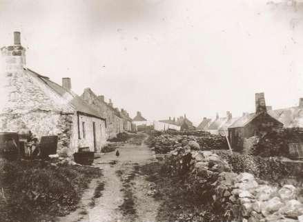
12th Century and Earlier
|
The next noticeable event in Portlethen’s history is likely to have been the nearby development of the Causey Mounth road in the 12th century. Originally there would have been a drover’s road in existence prior to the Causey Mounth becoming the principle highway between Stonehaven and Aberdeen. The Causey Mounth continued to be the main route between these two places until as recently as the mid 20th century by which time it started to be replaced by the road now known as the A90.
 As late as the early Middle Ages, the easternmost range
of the Grampian Mountains, posed a formidable barrier isolating the
northeast of Scotland from the Scottish Lowlands. This mountainous
barrier, combined with the local bogs, may have been a factor in
re-routing the Romans' coastal march northwards, since the northernmost
known major coastal Roman encampment at Raedykes, between Stonehaven and
Muchalls, lies literally at the southern latitude of the Causey Mounth.
By the twelfth century, construction of the Causey Mounth proper had
begun to connect these two regions of Highlands and Lowlands.
As late as the early Middle Ages, the easternmost range
of the Grampian Mountains, posed a formidable barrier isolating the
northeast of Scotland from the Scottish Lowlands. This mountainous
barrier, combined with the local bogs, may have been a factor in
re-routing the Romans' coastal march northwards, since the northernmost
known major coastal Roman encampment at Raedykes, between Stonehaven and
Muchalls, lies literally at the southern latitude of the Causey Mounth.
By the twelfth century, construction of the Causey Mounth proper had
begun to connect these two regions of Highlands and Lowlands.
The route was specifically designed to connect the coastal portion of Stonehaven to a crossing of the River Dee at the southern edge of Aberdeen. Stonehaven was most noted in the Middle Ages for the fortress of Dunnotar Castle, which controlled military land and sea movements from its rugged promontory jutting into the North Sea.
Proceeding north from Cowie Castle, the Causey Mounth crosses the Burn of Muchalls at the Bridge of Muchalls and then continues northward past Muchalls Castle. The track way passes the ruins of the Episcopal Chapels, dating to 1624 situated on lands of the Muchalls Castle Estate, and from there it continues northerly beside the present day Saint Ternan's Church, which succeeded the ruined chapels.
From there the alignment crosses the Pheppie Burn in an agricultural area and further crosses a bridge over the Elsick Burn at Gillybrands generally southeast of Elsick House. After crossing Portlethen Moss the route passes west of a massive megalithic standing stone, and from there onwards towards the River Dee.
There are surviving and usable sections of this road still in use today; however, many parts of this ancient route are no more than footpaths, and in some cases the road has vanished into agricultural fields. Much of the Causey Mounth was originally created as an elevated rock causeway to span many of the boggy areas such as Portlethen Moss.
An interesting footnote: The Causey Mounth road was traversed by William Keith, 7th Earl Marischal and the Marquess of Montrose when they commanded a Covenanter army of 9000 men, in the first battle of the Civil War - the Bishop’s War, at the Bridge of Dee in 1639.